This is the final installment of our vacation to Ambergris Caye with our long-time friends,
the Eternal Eight, comprised of Pam and Roy, Judy and George, Lori and Dean, and Dianna and myself. We first met years ago (this is our tenth anniversary) on a Windjammer Barefoot Cruise aboard the S/V Mandalay.
Today we set out to tour Bacalar Chico, the area making up the extreme northern boundary between Belize and Mexico, which follows the route of the ancient Mayan hand-dug canal from Chetumal Bay to the Caribbean Sea, cutting about 56 or so miles off the journey around Ambergris Caye for canoes hauling trade goods to the coast.
I had looked on Google Earth several years ago, seeing the Canal de Zaragoza, and wrongly assumed that to be the ancient Mayan canal.
What happened was that in 1897, a treaty was signed between Mexico and British Honduras (now Belize) establishing the boundary between the two countries and using the centerline of the ancient Mayan canal, dug in 65 CE, as that boundary. This apparently created a problem for the Mexican government, as they had to obtain permission from the British Honduran government to move Naval vessels into Chetumal Bay from the coast.
This embarrassing situation was fixed with the dredging of a new canal in 1899, the Canal de Zaragoza, thus giving Mexico free access by their Navy to Chetumal Bay.
 |
| Google Earth Map of Bacalar Chico Area |
Our journey took us from Debbie's Beach on the eastern side of Ambergris Caye, through the cut at San Pedro to the western side of the island, then north to Bacalar Chico, which we transited at the same time as we were hoping to see manatees. The Mayan canal meanders from lagoon to lagoon across the northern end of the Ambergris peninsula, creating the island.
While we were waiting for our tour guide, Dianna spent time with Ralf talking about his experiences over the past 16 years on Ambergris Caye.
 |
| Dianna Talking With Ralf Before Departure |
Right on time, Felix Alamilla, our tour guide showed up at the Debbie's Beach dock to pick us up.
 |
| Captain Felix and His Assistant, Edgar |
You can reach Felix at:
Felix Alamilla
Brisa del Mar Tours
501-666-2634
Brisa del Mar Tours on Facebook
He's a very good, conscientious and entertaining guide. We all highly recommend him.
 |
| Our Boat Has Arrived |
As soon as we boarded, Captain Felix explained how the day was going to unfold. He also wanted our input for what we wanted to accomplish during the day.
 |
| Captain Felix Explaining the Game Plan |
Soon after loading, we pulled away from the dock and were underway.
 |
| Departing From Debbie's Beach |
We ran down south to San Pedro to make two crucial stops. One to pick up a case of Belikin, which Edgar, Felix's assistant, quickly put on ice.
 |
| Edgar Stocking the Cooler |
The second stop was at Ambergris Divers, where we picked up our snorkel gear. Judy and George and Pam and Roy had brought their own, but the rest of us traveled lighter and had to rent.
 |
| Ambergris Divers - Picking Up Snorkel Gear |
Ambergris Divers is a very professional dive shop, with rentals, sales, offering dive packages, courses, etc.
 |
| Checking Out Our Gear |
Once we got all that taken care of we were underway once again, heading to adventure. We went westward through the San Pedro cut going underneath the toll bridge.
 |
| Through San Pedro Cut |
 |
| Under the Bridge |
And along the cut, there's a variety of houses and boats all with various moorages fronting the cut. We even saw an extremely fragile looking home-made and hand-powered ferry running folks back and forth across the cut.
 |
| Hand-Made and Hand-Powered Ferry |
 |
| Along the San Pedro Cut |
As we left the cut, we angled toward the south-west toward Cayo Espanto, a private island resort (
http://www.aprivateisland.com/), catering to the rich and famous. Ralf, our caretaker at Debbie's Beach, had managed Cayo Espanto for several years.
We pulled alongside a dock there, to pick up some bait fish and and tackle from a friend of Felix's who worked on the island.
 |
| Approaching Cayo Espanto - Private Island |
We didn't see anyone rich, or famous for that matter.
 |
| Coming Into Cayo Espanto For Supplies |
So, away we went up north about 20 miles to Bacalar Chico. We pulled in for our first stop at the San Juan Station, of the Bacalar Chico National Marine Reserve, where we were greeted by the station's kitty. We were informed he was quite ferocious, having bitten someone the day before. He seemed to be a real pussy cat for us, however.
 |
| San Juan Station Boss Cat - In Charge |
While there, we toured the small museum on the grounds of the station. It was quite good and informative too.
 |
| At the San Juan Station Museum |
 |
| Bacalar Chico Marine Reserve |
 |
| Bacalar Chico Palms |
This was the place where we learned most about the Mayan canal. It was dug in 65 AD. I never did find out how long it took them to dig it. I would imagine, a while for sure.
 |
| About the Canal |
 |
| Manatee Skeleton In the Museum |
 |
| About the Traders |
 |
| Departing San Juan Station |
Leaving the station, we passed a few sport fishermen, a very popular activity on the canal - probably even from the Mayan times to the present.
 |
| Fishing in the Canal |
Felix allowed us time for fishing at various spots along the way. Although, to be honest, that wasn't the focus of our group. Even so, we still managed to snag a couple of barracuda for Felix and Edgar to take home for the evening meal.
 |
| Some Barracuda For Supper |
 |
| Start of a Nice Meal |
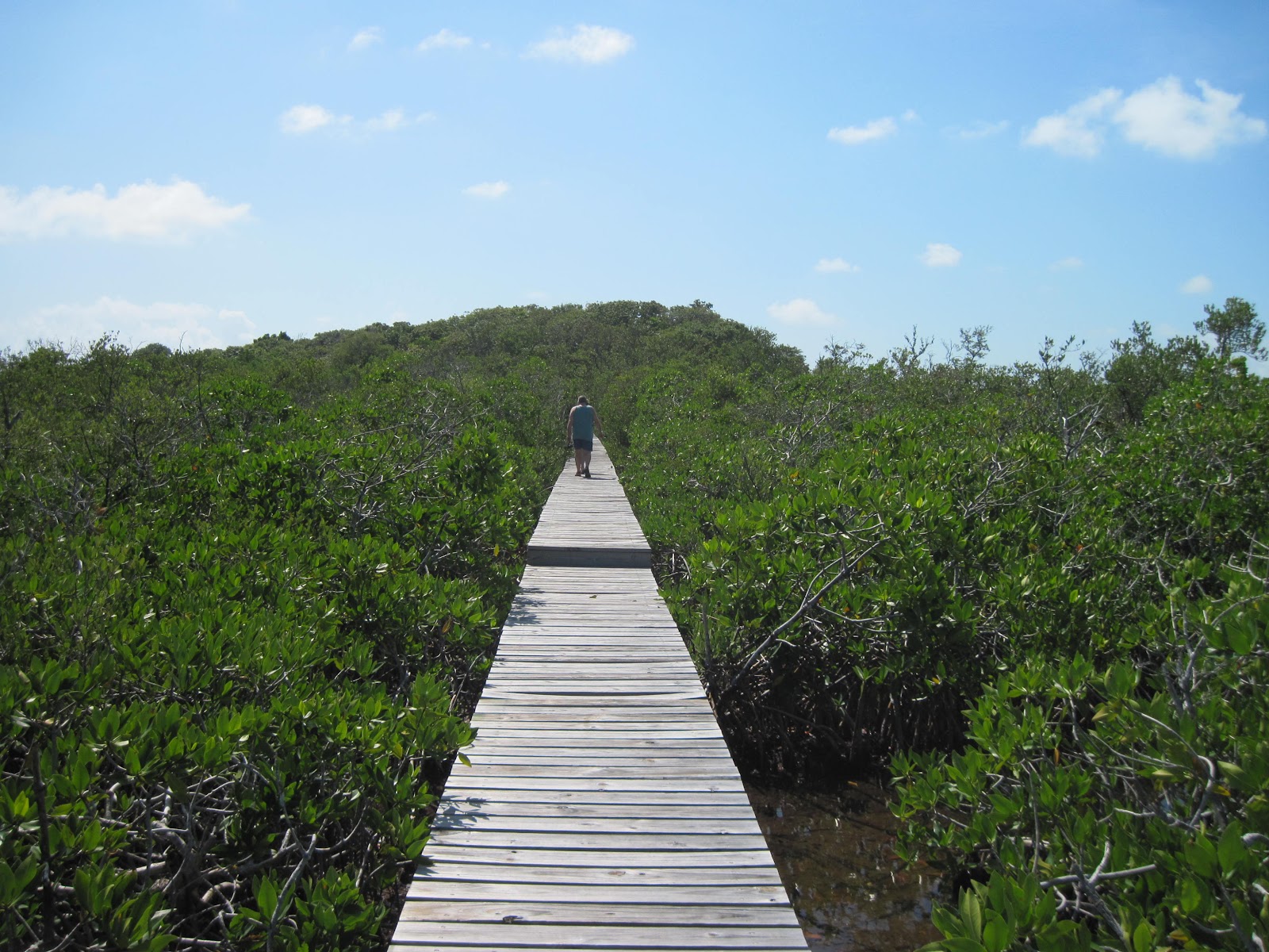
Our next stop was a bit further into the Mayan canal, at the Chaac Balam Archeological Site. We moored to a wooden walkway that traversed a low mangrove swamp. The boardwak led to the mound that is being excavated.
 |
| Boardwalk Moorage Chaac Balam Site |
It's a fair walk, not too far and really kind of easy. Make sure to slather on the bug juice. The mosquitoes love tourist blood.
 |
| Boardwalk to the Chaac Balam Excavations |
Here's Judy hiking up the mound. Bugs and all, it's not a bad hike at all.
 |
| A Buggy Walk at Chaac Balam |
And George, who's being careful where he steps.
 |
| Exploring the Excavations |
Several signs describe what is taking place in the area.
 |
| Trench Excavations at Chaac Balam |
There are quite a few excavation sites in the area and it pays to follow George's advice and not fall into one of them.
 |
| Chaac Balam Excavation Pit |
 |
| Small Excavation at Chaac Balam |
 |
| Mayan Excavations Chaac Balam Site |
We didn't see any archeologists at work, although several of the trenches did look to be fairly fresh.
 |
| Trench Excavation |
 |
| Explaining Burial Platforms |
 |
| Chaac Balam Excavations Burial Site |
After leaving Chaac Balam, we started to explore the canal once again, keeping an eye out for manatee.
We did find an abandoned boat, which didn't look to me to be in that bad a condition.
 |
| Abandoned Boat In Canal |
We explored several small inlets along the way of the canal, looking for the elusive manatee, which we never saw.
 |
| Exploring a Narrow Channel |
We did manage to see lots and lots of other fish in the canal's clear waters.
 |
| Roy Watching for Fish |
As we left the canal, we stopped for lunch at a beach area of the national park. They have a very nice and well-made dock, along with very nice sandy beach area. Unfortunately, with the common problem of trash at the water's edge.
 |
| National Park Landing |
 |
| Welcome Sign |
Edgar made sure to hurry up with some rum punch drinks and other delights for our hungry and thirsty crew.
 |
| Edgar Bringing Drinks Ashore |
By now, the beer was properly chilled and we availed ourselves of that beverage post-haste.
 |
| Dean Heading to the Cooler |
Soon after arriving, Felix broke out the conch ceviche, which, along with the beer, really hit the spot. But this was just the appetizer, the preliminaries, as you might say.
 |
| Ceviche time On the Tour |
Some wag immortalized our group in sand graffiti. Well, at least till the next rainfall.
 |
| E8 in the Sand |
Shortly thereafter, Felix surprised us all with an excellent BBQ lunch of grilled grouper and wahoo with veggies and all the trimmings. I must say, it was truly excellent.
 |
| Felix Unveiling Lunch |
There was plenty to go around for all hands. Quite a phenomenal feast, right there on the beach.
 |
| Felix Dishing Out BBQ Lunch |
After lunch, there was some time left for just lazing around and soaking up sun, for those so inclined.
 |
| George and Judy Enjoying the Day |
 |
| Lori Enjoying Lunch Break |
After a quick siesta, it was back into the boat and back into the canal for a quick look-see for the manatee.
 |
| Hunting Manatee in the Canal |
 |
| Exploring the Canal |
 |
| Watching for Manatee |
After that, we headed back out the east side of the island toward the reef for some snorkeling. We anchored about 10 or 15 feet way from the breaking surf.
 |
| Anchored At the Reef |
The snorkeling was good, although a bit rough for Dianna and me. Judy, George, Pam and Roy found it wonderful.
 |
| Judy Ready to Snorkel |
 |
| Judy In the Water |
After everyone was tired from snorkeling, we headed back through the canal and south toward San Pedro.
 |
| Nearing the End of the Day |
Here we are coming under the bridge at the San Pedro cut, just before sunset, and returning our snorkeling gear and a crate full of empty Belikin bottles. Felix then took us north back up to Debbie's beach. The perfect end to a perfect day.
 |
| Returning Under the Bridge |


2 comments:
Wow, what a day. Glad you shared it with us folks that still need a jacket at night. But it is going into the 70's tomorrow!!
Nice blog Dave.
Julian
Thanks Julian. We were 'plum tuckered out' at the end of that day. However, in true vacation-style, we still managed to find enough energy to go out for dinner in spite of the full day already expended.
Cheers,
Dave
Post a Comment